INDIA DEFENCE CONSULTANTS
|
WHAT'S HOT? –– ANALYSIS OF RECENT
HAPPENINGS |
|
INDIA CHINA RELATIONS An IDC Analysis
|
|
New Delhi, 18
June 2003
In his fascinating style Mohan Guruswamy traces the history of the India-China border dispute and brings us up to date on the events from British times to the present day. The facts of the case are that the border between the two countries was never formally defined and had remained a loosely conducted exercise with various lines drawn on maps by the British, as they played the Great Game with the Soviets. While it may be possible to settle the border in the Eastern Sector on the basis of the clearly demarcated McMahon Line, there is little chance that the Chinese will hand over the Aksai Chin in the West. It is also highly unlikely that we can take this area by military means. Mohan suggests the the Chinese may be willing to settle along these lines. He suggests that the Government sees the reality and settles this issue devoid of sentimentality and an untenable legalistic belief about the ownership of an inhospitable territory 'where not a blade of grass grows'. No Longer a Great game By Mohan Guruswamy The roots of our
problem with China go back a couple of hundred years when the
Emperor Napoleon and Tsar Alexander, met in July, 1807, on a great
raft moored on the river Niemen at Tilsit in east Prussia, to
conclude a treaty of partnership against the British, thereby
beginning “The Great Game.” This expression was first found in
the papers of Arthur Connolly, a British artillery officer and
adventurer whose ‘Narrative of an Overland Journey to the North of
India’ chronicled his travels in the region in the service of the
British Empire. As the Russian Empire began its eastward expansion,
which many opine was to culminate in the conquest of India, there
was a shadow contest for political ascendancy between the British
and Russian empires – The Great Game. Napoleon’s waterloo
at Waterloo did not see a let up in the fervour with which the game
was played. The Russians longing for a colonial empire and a warm
water port did not diminish any and so the game continued. The
British response to meet the Russian threat was to establish a
forward defensive line in the northern region so that a Russian
thrust could be halted well before the plains of Hindustan. This called for making
Afghanistan and Tibet into buffer states and for the fixation of
suitable and convenient borders with these states. At various times,
several such lines were proposed. The most notable of these was the
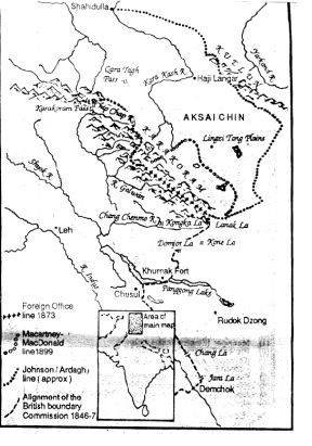
1865 Ladakh-Tibet/Sinkiang alignment proposed by W.H. Johnson, a
junior civilian sub-assistant with the Survey of India. This line
was to link Demchok in the south with the 18,000 feet high Karakorum
pass in the north, but it took a circuitous route beyond the Kuen
Lun Mountains and thus included the barren and cold Aksai Chin
desert. It is believed that
Johnson may have had some personal reasons too for doing this. He
was an Indian born “Englishman”, and in the subtle social
graduations that guided an individual’s destiny under the Raj,
there were limits to where he could go. Johnson could not aspire to
either a commissioned rank or a high civilian status with the Survey
of India and what better way to improve his prospects than by
entering the Kashmir Maharaja’s service? By greatly enlarging the
size of the Maharaja’s domain by incorporating Aksai Chin, Johnson
caught the Maharaja’s eye.
Map
showing the disputed areas in western sector Johnson’s
survey is not without some controversy. To have completed the
journey to Khotan, which lay well beyond the forbidding Kuen Lun
range, and to return to Leh in the time he did, he would have had to
be covering over 30 kms a day. Even if that frenetic pace were
possible, it is doubtful any serious survey effort would have been
possible. Apart from this there was the question of the
disappearance of a consignment of silver ingots, the Khan of Khotan
had sent with him as a gift to the “Lord Sahib” in India. Having
thus become somewhat of an embarrassment, he was passed over for
promotion. Before long he resigned from the Survey of India and
entered the Maharaja’s service. He did well here and rose to
become the Governor of Ladakh. Not a bad reward at all for
“giving” the Maharaja an uninhabited 18000 sq. kms! That the British were
undecided about Johnson’s line is evident by the recommendation in
1889 by Ney Elias, Joint Commissioner of Leh. Elias who was an
authority on trans-Karakorum territories advised against any
implicit endorsement of the Johnson line by a claim on Shahidulla in
the far off Karakash valley about 400 kms from Leh, as it could not
be defended. On the other hand, responding to Capt. Younghusband’s
report on his meeting with the Russian explorer, Col. Grombchevsky
near Yarkand, Maj.Gen. Sir John Ardagh, Director of Military
Intelligence at the War Office in London recommended claiming the
areas “up to the crests of the Kuen Lun range.” Before Whitehall
could make up its mind, the Chinese occupied Shahidulla in 1890. To
this the opinion of the Secretary of State for India in Whitehall
was: “ We are inclined to think that the wisest course would be to
leave them in possession as it is evidently to our advantage that
the tract of territory between the Karakorum and Kuen Lun mountains
be held by a friendly power like China.” The Indian case for
ownership of the Aksai Chin or the white desert rests essentially on
the cartographic exertions of a man such as Johnson and we must
begin to think about its validity. It’s also not without some
irony that another Kashmir Maharaja’s grandiose dreams of an
independent state resulted in India’s other major problem with
another neighbour. Though Jammu and
Kashmir was an independent kingdom, the 1846 Treaty of Amritsar gave
the British the responsibility of its security. This made the
British responsible for Kashmir’s northern and eastern borders
with Sinkiang and Tibet. The British, however, never really got
around to fixing the border along this line. In 1899, another line
was suggested. This was the MacCartney-Macdonald line that excluded
most of the Aksai Chin. The British tried to get the Chinese to sign
an agreement to this effect. The Chinese did not respond to these
moves and Lord Curzon concluded that their silence could be taken as
acquiescence and decided that henceforth this should be considered
the border, and so it was. Interestingly this line, by and large,
corresponds with the Chinese claim line, which in turn, by and
large, coincides with the Line of Actual Control. But in 1940–41,
things began to change again. British intelligence learnt that
Russian experts were conducting a survey of the Aksai Chin for the
pro-Soviet Sinkiang government of the warlord Sheng Shih-tsai. It
was obviously time for the Great Game again. Once again the British
went back to the Johnson claim line. But nothing else was done to
clearly demarcate the border. No posts were established in Aksai
Chin and neither were any expeditions sent there to show the flag,
as is normal in such situations. For all practical purposes the Raj
ceased at the Karakorum range, but by the rules of the Great Game it
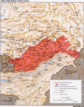
went further beyond just in case… On the eastern sector
the Game was also being played, but a little differently. In 1826,
the British annexed Assam, which then mainly meant the Brahmaputra
valley. The hills were first penetrated in 1886 when an expedition
went up the Lohit valley at the far end of what is now Arunachal
Pradesh. But in the western end of this sector, immediately east of
Bhutan, a Tibetan administered wedge known as the Tawang tract
coming alongside the east of Bhutan up to its southern alignment and
running eastwards till just west of Bomdila, was considered by the
British to be open country. In 1903, Lord Curzon
concluded that Tibet too had now become a possible launching pad for
a Russian thrust and by the rules of the Great Game the Russians
were to be pre-empted. Thus came about the celebrated Younghusband
mission to Lhasa the following year. But in 1907, the British and
the Russians came to an agreement that it suited both their
interests to leave Tibet “in that state of isolation from which,
till recently, she has shown no intention to depart”. Thus Tibet
like Afghanistan was to be a buffer state between the two European
imperial powers. But by mid 1910, the Chinese were back in Tibet
exercising full control. This reassertion of Chinese power caused
concern to the British once again. A consequence of this was a
renewed urgency to the perceived need to have a buffer between the
Chinese and the precious British investments in Assam. Another forward line
was now mooted. This line called the Outer Line included the entire
tribal belt except the Tawang tract. Though the then Viceroy, Lord
Hardinge, initially saw this as incurring too many risks and
expenses, in 1911 citing the Chinese policy of expansion as a cause,
he ordered the establishment of “a sound strategical boundary”.
Thus by September 1911, the British had decided that the Outer Line,
but now including the Tawang tract, should be the boundary with
Tibet-cum-China. With the collapse of
the British and Soviet empires, the only inheritors of this squalid
and sometimes bloody game are the Chinese and Indians. The other
significant difference is that it is no longer a game played by
armchair empire builders in Europe with their assortment of secret
agents, cartographers, commercial travellers and explorers, but a
deadly serious game between the world’s two largest nations with
the fastest growing economies, and two of the world’s major
military powers made even more formidable with openly deployed
nuclear forces. The prize now is no longer an entire subcontinent,
but merely a barren and desolate desert high amidst cold wind-swept
mountains where, in Jawaharlal Nehru’s words, “not even a blade
of grass grows”. II
Is
there an Indian case?
The next major
development with China and Tibet was when the British called for a
conference at Simla in October 1913. The Chinese attended
reluctantly, but the Tibetan authorities came quite eagerly as they
were now engaged in conflict with their Chinese suzerains. Henry
McMahon, Foreign Secretary to the “Government of India”, led the
British delegation. McMahon was some sort of an expert at drawing
boundary lines, having spent two years demarcating the Durand Line
as the North-west frontier. The boundary that
followed was the now famous McMahon Line. This boundary now extended
British India up to the edge of the Tibetan plateau. It was not
really a cartographers delight as it violated several rules of
boundary demarcation. But it was an ethnic boundary in the sense
that the area, except for the Tawang tract, was non-Tibetan in
character. The Chinese, however,
soon repudiated the Simla Convention and thus the McMahon Line. All
through this period the British never challenged Chinese suzerainty
over Tibet. The new boundary was not made effective till Olaf Caroe,
an ICS officer, in 1935 urged the British authorities to do so. Thus
in 1937, the Survey of India for the first time showed the McMahon
Line as the official boundary. But confusion still abounded. In 1938, the Survey of
India published a map of Tibet, which showed the Tawang tract as
part of that country. Even the first edition of Jawaharlal Nehru’s
“Discovery of India” showed the Indo-Tibetan boundary as running
at the foot of the hills. The Tibetans however, did not accept this
“annexation” of the Tawang Tract and challenged the British
attempts to expand their government into this area. They, however,
tacitly accepted the rest of the McMahon demarcation. It is,
however, clear that but for the Tawang tract there is little basis
for the Chinese claim on the whole of Arunachal Pradesh. Even the
claim they might have on the Tawang tract is rendered invalid in the
sense that it becomes a geographical anachronism and incompatible
with India’s security interests. The Japanese thrust
towards India in World War II gave urgency to the British need to
fix this boundary firmly and securely. Thus in 1944, J.P. Mills, the
government’s advisor on tribal affairs established a British
administration in the entire belt from Walong in the east to Dirang
Dzong in the west. Several posts of Assam Rifles were established
and soon Tibetan government officials were packed off from the
Tawang tract also.
The
Eastern Sector This was the state of
the Great Game when the British left India. In 1949, the communists
came to power in China and shortly thereafter the Peoples Republic
announced that its Army would be moving into Tibet. India reacted by
sending the Chinese a diplomatic note. Soon after receiving this
angry protest note the Chinese occupied Tibet. The Chinese said:
“Tibet is an integral part of China and the problem of Tibet is a
domestic problem of China. The Chinese Peoples Liberation Army must
enter Tibet, liberate the Tibetan people, and defend the frontiers
of China”. India had hoped to persuade the Chinese to desist by
offering to take up their case for membership in the UN in place of
the Kuomintang Chinese left on Formosa! The Chinese rejected this
absurd quid pro quo and said these two issues were unconnected. The purpose of this
laborious recitation of the events of nearly a century and a half of
the Great Game is to only show that the borders were either never
clearly demarcated or established. Lines kept shifting on maps as
political contingencies arose. The Indian people were, for this
entire period, passive spectators to these cartographic games. But in 1947, the
British finally left India. Our choice then was to either call an
end to the Great Game or continue playing it with all the intensity
and commitment it called for. We did neither. When the Chinese
Communists occupied Tibet, we acquiesced. And neither did we firmly
move into the areas claimed by the British as Indian Territory,
particularly in the western sector. How well we looked after
territory we claimed as our own is seen by the fact that in the
early 1950’s the Chinese had built a road connecting Tibet to
Sinkiang across the Aksai Chin, and we did not have a clue about it
for several years. The Indian government,
however, did move into the Tawang tract in force in 1951, overriding
Chinese/Tibetan protests. In this sector, at least, it was clear
that the Indian government was firm about its control of all the
territory claimed by the British. The Chinese also seemed to have
now accepted the McMahon Line as the boundary in this sector as
there are several indications of this effect. The situation in the
western sector, however, was entirely different. Here no definite
British Indian boundary line existed. The only two points accepted
by both sides were that the Karakorum Pass and Demchok, the western
and eastern ends of this sector, were in Indian Territory. Opinion
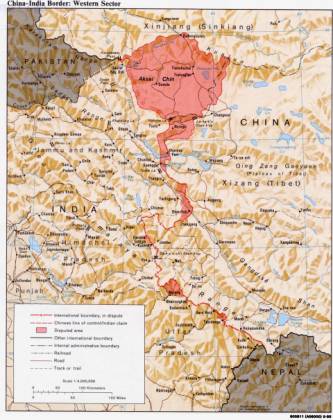
on how the line traversed between the two points differed. India’s boundary was
inclined towards the Johnson claim line whereas as the Chinese,
having built their road through the Aksai Chin naturally preferred
an alignment closer to the McCartney/MacDonald line of 1899. The
Chinese claim line however went further west and included the Chip
Chap valley, Samzungling, Kongka La, Khurnak Fort and Jara La. More
importantly, as far as the Great Game was concerned, the Chinese
were in occupation of all this territory by the early 1950s. This is how matters
were by the end of 1952 and by and large how things are today. The
Chinese hold all territory, give or take some, within their claim
line in Ladakh and in the east India holds most of the territory
below the McMahon line give or take some. These de facto boundaries
could have been a basis for a permanent settlement of our
boundaries. But we did not pursue it though time to time there were
indications that the Chinese might want to settle on this basis. Now the question that
arises is: Why did the Government of India not extend its control to
the boundaries it claimed in the western sector as it did in the
east? This was mostly due to the terrain. The boundary claimed lies
beyond two high mountain ranges and is logistically impossible and
militarily indefensible. Besides the Chinese were already in control
of much of the area by 1951. The question then is: Why did the
Government of India not make serious diplomatic or military efforts
to assert control over territories, it believed was ours? The answer obviously
lies in the fact that legally there was not a very good case and the
military price this barren uninhabited windswept desolation would
demand did not make it a worthwhile cause. Yet in spite of all this
there abounded the zealous spirit with which recently freed nations
regarded their inherited boundaries that often were without regard
to geography, ethnicity and history. Even in 1954, the most advanced
Indian post was at Chushul and barring a couple of patrols to Lanak
La no attempt was made to show the new flag. Even Lanak La was well
south of Aksai Chin and short of the Sinkiang–Tibet highway, which
passed east of it at that point. The main rule of the
Game for the previous 150 years was that it be played quietly and as
surreptiously as possible. In the 1950’s these rules still seemed
to prevail and the two contesting governments decided to keep the
lid on the problems while jockeying around for local advantages. On
the surface it was all Hindi-Chini bhai-bhai and the practice of the
Panchsheela philosophy, but underneath was the realisation that the
titles to large tracts of territory under the control of both
parties were under dispute. The lid blew away when in March 1959 the
Dalai Lama fled to India and was given political asylum. III
Can we now
settle this?
The Dalai Lama’s
flight to India was followed by two ominous incidents. On August 25,
1959, Indian and Chinese forces clashed over possession of Longju, a
small village in the eastern sector. We said it was on the McMahon
line and, therefore, ours, the Chinese said it was two miles north
of it and, therefore, theirs. There were a few casualties on both
sides. On October 20 the same year, the Chinese at Kongka La
ambushed an Indian patrol sent to probe the Aksai Chin, in which
nine Indian frontier policemen were killed and seven taken prisoner.
With this, Indian public opinion was inflamed. A democracy is
nothing but a government sensitive to public opinion and governments
that ignore this do so at its own peril. But public opinion, even
when not inflamed, is quite often ill informed. Even many among the
leadership never really understood the historical background of the
dispute. We claimed that what
the Chinese were claiming and occupying was our “sacred land”
and this was accepted by almost all, except the doctrinaire Marxist
Communists who may have done this for reasons not at all related to
history. The Indian government knew better, but allowed itself to be
swept by the tide of public opinion, and true to the manner the
great game of democracy is played here, the opposition did nothing
to bail it out. The influence of the
domestic imperative in the international politics of democratic
countries must never be underestimated. It is also an inherent
characteristic of democratic societies that very little flexibility
is given to the decision-makers in choosing a policy from a wide
spectrum of options. If for instance, Nehru accepted Chou-en-Lai’s
offers of a settlement on a give and take basis, he would have been
accused of giving up our “sacred” territory. As it is the
opposition was exploiting Nehru’s discomfiture over his failed
China policy and his naïve reliance on Hindi-Chini bhai-bhai and
Panchsheela with the worlds foremost practioners of realpolitik. In the highly partisan
atmosphere that characterized our politics then, as it is even now,
any stick is good enough for the opposition to beat the government
with and vice versa. The opposition, then though small in numbers,
made up for lack of quantity by quality. Eminent leaders, known for
their incisive intellects and oratorical abilities, like Ram Manohar
Lohia, Acharya Kripalani, Asoka Mehta, Deendayal Upadhyaya, Minoo
Masani and C.Rajagopalachari, all smarting at their electoral
inconsequence tore into the government in parliament and outside.
Some others like Atal Behari Vajpayee were well known for their
fiery demagoguery. Many of Nehru’s
colleagues, upset by his “loftiness” and his fondness for
Krishna Menon, often preferred to be bemused observers enjoying
these blistering attacks. China was treated as Nehru’s problem. To
be fair to them, Nehru for long had kept the problems with China to
himself as he did with most matters pertaining to external
relations. To get over this uncomfortable “debating” situation
in parliament, Nehru often had to sound tough and uncompromising.
This would have been fine, if he had the military strength to back
him up. Unfortunately for the country, this was not so. The Indian Army then
was poorly equipped, short-staffed and generally in a bad way.
Krishna Menon as defence minister squabbled with the generals in
public and wrought havoc with the morale of the brass. Aiding him in
good measure was a Nehru kinsman, Lt Gen B.M.Kaul, a soldier with no
combat experience, who in his bid to be one up over his peers, would
agree to do things the politicians wanted done, but the general
staff baulked at. The press in those
troubled days was not very helpful either. The major English
language papers almost in unison shrilly demanded that the Chinese
be expelled and often accused the government of not doing its duty.
The influential English language media with few notable exceptions,
being still conditioned by their pro-British past was generally
pro-Western and thus found this a good opportunity to needle the
government on its policy of non-alignment seen by them in Dullesian
terms as being pro-Soviet. The editors and pundits, never
comfortable with Nehru’s non-alignment went hammer and tongs at
him. Given this atmosphere, partisan political interests took
precedence over national interests. This is not unfamiliar even
today. The need to develop a non-partisan national consensus based
on a rational survey of facts and events never was greater, yet was
as far as it often seems even now. Against this
surcharged backdrop, Nehru had to come up with something. This
something was the Forward Policy. This policy called for
establishing posts in the disputed areas often behind the Chinese
line of forward posts. Thus a number of small forward posts were set
up with meagre resources, poor communications and extremely
vulnerable supply lines. Most of these posts had to be supplied by
air drops and quite a bit of the supply would end up in Chinese
hands and often the PLA would hand these over to our men to derive a
psychological advantage. Nothing describes the
Forward Policy better than the words of an Indian Army officer:
“We thought it was a sort of game. They would stick up a post and
we would stick up a post and we did not think it would come to much
more”. It came to be much more, as it had to, and the consequences
were felt in 1962 when a full-scale border war broke out. The
Forward Policy was against all sound military advice. Lt. Gen. Daulat
Singh’s, GOC, Northern Command in a memo to the government on Aug
17, 1962 bitterly criticized this policy. He wrote: “It is
imperative that political direction is based on military means”.
Daulat Singh’s warning like those of many other senior officers
was ignored. Defence Minister Krishna Menon, Intelligence Bureau
Director B N Mullick and Lt Gen B M Kaul who had conjured up this
policy, had Nehru’s ear and that was what mattered. If Nehru had
learnt a little from the much-publicized Bay of Pigs fiasco the new
American administration of John Kennedy had landed itself into in
1961, he would have been very wary of this threesome. In Kennedy’s case,
he allowed the legendary Richard Bissell, the CIA’s director of
operations, awe him, his cabinet and his military chiefs into
approving an operation that was based on little hard intelligence
and a lot of wishful thinking. Also in Kennedy’s case the
pressures of the domestic imperative was overwhelming. The planning
of the operation had begun in Eisenhower’s time with Richard Nixon
playing a leading part in it. If Kennedy aborted the plan he would
have been accused of being “soft on communists” and what greater
crime can there be in that bastion of “freedom and liberty” than
this? He succumbed to the fear of an inflammable public opinion just
as Nehru was to do later. In both cases, the policies ended up as
unmitigated disasters that almost irretrievably hardened positions
and thus shaped the future course of national direction and domestic
politics. Incidentally, the
order to “throw the Chinese out”, was given on September 22,
1962 by K Raghuramiah, then Minister of State in the Defence
Ministry. Raghuramiah was in the chair, Krishna Menon being in New
York to deliver yet one more of those long harangues he was so fond
off, when the Army Chief, Gen. KN Thapar gave his appreciation of
the situation in the Dhola area. The Foreign Secretary then gave his
appreciation that the Chinese were unlikely to react strongly and
for good measure repeated the Prime Ministers “instructions” on
the subject. And so we went to war! In the 38 years that
have followed the debacle of 1962, little has changed. We in India
have not yet been able to get together a non-partisan consensus on
crucial issues such as this. We do not seem to have as yet grasped
the real and futile nature of the border dispute. In an over
populated, overcrowded and primarily agricultural country with a
relatively small landmass to share, the concern and obsession with
land is understandable. Land is our primary economic resource and
hence it is an ingrained national characteristic to be possessive
about land. Our leaders, notorious for their land grabbing ways, not
surprisingly have acquired an estate agents mentality as far as
territory goes. It seems that to us country no longer means people
but land. Or else why would we care so little about our people and
their interests and honour, and care so much for an uninhabitable
desert? While it is possible
for us to settle our eastern border disputes with China on the basis
of a clearly demarcated McMahon line, there seems little or no
chance that the Chinese could be persuaded to handover Aksai Chin to
us, and thereby de-linking Tibet from Sinkiang. There also seems an
equally remote chance that we might be able to retrieve it from the
Chinese by military means. Even if we summon the political will to
stake a fortune, the sheer lack of any tangible benefits, material
or spiritual, will only make this even more foolhardy.
Aksai
Chin in the Western Sector There are many
indications that the Chinese would settle along these lines. We in
India still seem prisoners of our past and continue to take an
excessively legalistic view of past events and present inheritances.
We have even bound ourselves in knots with a jingoistic and
unrealistic parliamentary resolution that binds us to an undefined
boundary bequeathed to us and to the “liberation” of occupied
territory, so desolate and inhospitable that let alone animal life,
even plant life is hard pressed to exist upon it! By freeing
ourselves from this mindset we could meaningfully negotiate a
settlement with the Chinese, whose only aim in this sector seems to
secure the Sinkiang-Tibet highway through the Aksai Chin. While this
will not entirely dissipate the rivalry between the two countries it
will remove a cause of frequent tension that only serves to
underline our unfavourable strategic position. The challenge now for our national leadership is to harmonize reality with sentiment, pragmatism with unhistorical belief and national aspirations with imperialistic legacies. To be able to do this we first need to extricate such sensitive and critical issues from the ambit of partisan politics. The responsibility for this lies with the government of the day, which alone can orchestrate such an exercise. By doing this, we can once again bring into alignment our political objectives, with military means and reality. We can then negotiate from a position of strength and give ourselves secure, defensible and natural boundaries in the north at least. And who knows this may even lead to lasting good relations between the two great countries.
|